JSAE EXPO 2026 NAGOYA Coverage.While expectations are rising for the
practical implementation of Level 4 autonomous driving mobility services, systems that rely solely on onboard sensors have their limitations. Furthermore, ensuring safety in so-called “sensor blind spots”—such as pedestrians, cyclists, and vehicles parked on the street at intersections with poor visibility—remains a major challenge.
The key to solving this problem lies in “Cooperative Perception” technology, which shares sensor data from roadside units and other vehicles.
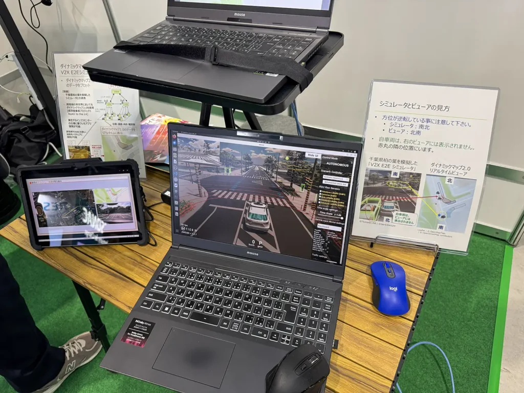
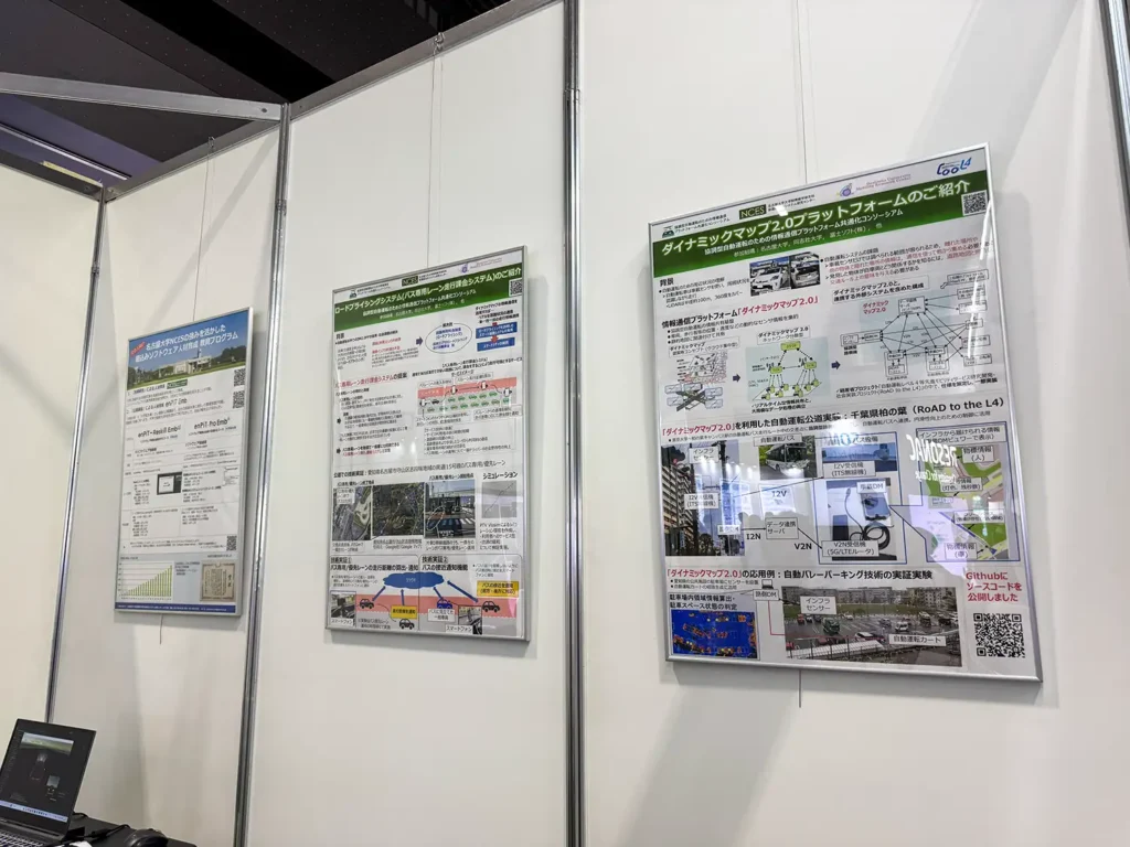
In particular, “Dynamic Map 2.0,” developed by a research consortium at Nagoya University, is an information and communication platform that integrates and aggregates dynamic information on vehicles and pedestrians (such as location and speed) with static maps, and shares this data in real time.
1. Key Features of “Dynamic Map 2.0”
Collaborative Perception to Eliminate “Blind Spots” and a “Decentralized” Architecture
- Overcoming the Limitations of Single Sensors: Achieving “collaborative perception” by communicating with roadside equipment (infrastructure) and other vehicles to compensate for blind spots at intersections and areas obscured by parked cars—which cannot be detected by a vehicle’s sensors alone.
- Ensuring Real-Time Capability Through a “Network-Distributed” Approach: The system employs a mechanism that distributes processing across the cloud, the edge, and vehicles. This prevents delays caused by large-scale data processing and enables the real-time sharing of information necessary for collision avoidance and other functions.
A proven track record and “free release” of source code
- Real-world implementation results: The system has already demonstrated its effectiveness in specific real-world settings, such as providing intersection information to autonomous buses in Kashiwanoha, Chiba Prefecture, and enabling automated valet parking at public facilities in Aichi Prefecture (including the calculation and sharing of information on available parking spaces within parking lots).
- “Democratization” through free release on GitHub: The source code (under the MIT license) and API specifications for the developed platform are publicly available. This eliminates the need for local governments and transportation operators to develop expensive systems from scratch, dramatically lowering the barriers to adoption.
Scalability to “Next-Generation Transportation Services” That Go Beyond Autonomous Driving
- The research goes beyond simply supporting safe driving and incorporates considerations for future business development.
- For example, it includes concepts for monetization and service development that form the foundation of smart cities, such as integration with autonomous driving systems (information sharing with end-to-end AI), expanded automated valet parking, road pricing (toll systems), and micropayment functions for dynamic map usage fees.
Its Role as a “Common Foundation (Area of Collaboration)” to Prevent Japan’s “Galápagos Syndrome”
- Taking the form of a “consortium” through industry-academia-government collaboration, its primary objective is “standardization.” By serving as the foundation for “areas of cooperation”—which the entire nation should embrace—rather than “areas of competition” where companies develop independently, this initiative will be a crucial step for Japan’s mobility industry as a whole to compete on the global stage.
2. About the Consortium
The official name of the consortium that developed “Dynamic Map 2.0” is the “Consortium for Standardizing Information and Communication Platforms for Cooperative Autonomous Driving.”
This is a successor project that evolved from the “Consortium on Technologies for Enhancing the Reliability of Dynamic Map 2.0,” which was led primarily by Nagoya University and Doshisha University; its activities now focus on social implementation, standardization, and widespread adoption.
- Joint Activities: Promote the development and standardization of an information and communications platform for cooperative autonomous driving. Additionally, jointly implement new transportation services and conduct demonstration experiments (scheduled to take place in Takakuraji, Kasugai City, Aichi Prefecture, among other locations) aimed at optimizing urban transportation.
- Individual Initiatives: Based on the specific challenges faced by participating organizations, we provide tailored support—such as developing integration features between their products and Dynamic Map 2.0, collaborating on external pilot tests, and training technical staff.
3. “Coordination” and “Ongoing Support” to Compete on the World Stage
The consortium has a three-year plan through March 2029 and appears set to move forward with more advanced technology demonstrations, such as integrating autonomous driving systems with end-to-end AI and upgrading communication protocols (to QUIC).
However, for Japan to compete with other countries—such as those in Europe, the United States, and China—in this field and achieve true societal implementation, it will likely need to overcome two major obstacles—namely, “sustained national investment” and “industry collaboration”—even more than technological development itself.
In recent years, it has been pointed out that, as a matter of national policy, priority has shifted toward supporting other areas, resulting in a relative dilution of budgets and resources allocated to collaborative mobility infrastructure. Compared to overseas players such as China, which are rapidly advancing the smart transformation of entire cities backed by massive government budgets, this disparity in budgets and resources could directly lead to delays in progress.
Another cause for concern is the “lack of coordination” among domestic mobility companies.
For example, some major companies are pursuing their own independent research, raising concerns about the fragmentation of resources and duplicate investment within Japan.If major companies go their own way, the hard-won open, shared platform will end up isolated. Under such circumstances, the dream of competing on the global stage with technology developed in Japan will remain just that—a dream.
I’ve listed two things that are urgently needed right now to compete with the overwhelming speed and scale of overseas operations.
- Further Strengthening of Financial and Policy Support for the Infrastructure Coordination Sector
- A collaborative approach that transcends corporate boundaries and unites the entire nation on a common platform (area of cooperation)
Now that “Dynamic Map 2.0” has been released free of charge, government agencies should strengthen their ongoing support rather than treating this as a one-off research project, and business leaders should clearly distinguish between the realms of “competition” and “cooperation” to bring together the full strength of the domestic mobility industry.I look forward to seeing drastic, coordinated efforts by
both the public and private sectors to transform these pilot projects into widespread societal implementation.
[Reporting, Writing, and Photography]
The mono-think Editors
A web media outlet that explores the cutting edge of Japan’s “manufacturing” and “infrastructure” from the perspective of active IT engineers, offering a unique perspective.
[Research Cooperation & Related Links]
Open SDV Initiative
JSAE